5. Input grid types
[1]:
import earthkit.data
import earthkit.maps
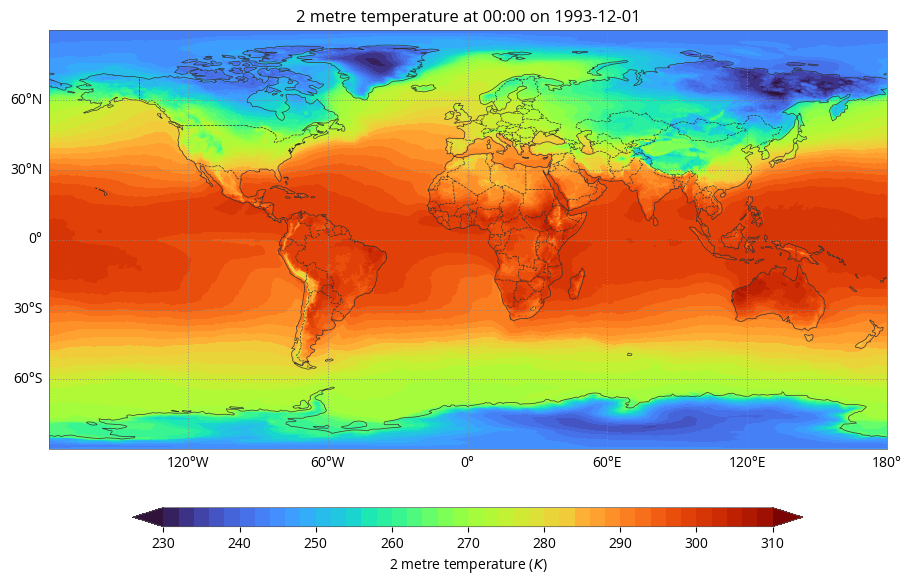
Equirectangular latitude-longitude projection
[2]:
earthkit.data.download_example_file("era5-2m-temperature-dec-1993.grib")
data = earthkit.data.from_source("file", "era5-2m-temperature-dec-1993.grib")
[3]:
earthkit.maps.quickplot(data)
{'central_longitude': 0.0}
{'semimajor_axis': 6378137.0, 'ellipse': 'WGS84'}
{'central_longitude': 0.0}
{'semimajor_axis': 6378137.0, 'ellipse': 'WGS84'}
{'central_longitude': 0.0}
{'semimajor_axis': 6378137.0, 'ellipse': 'WGS84'}
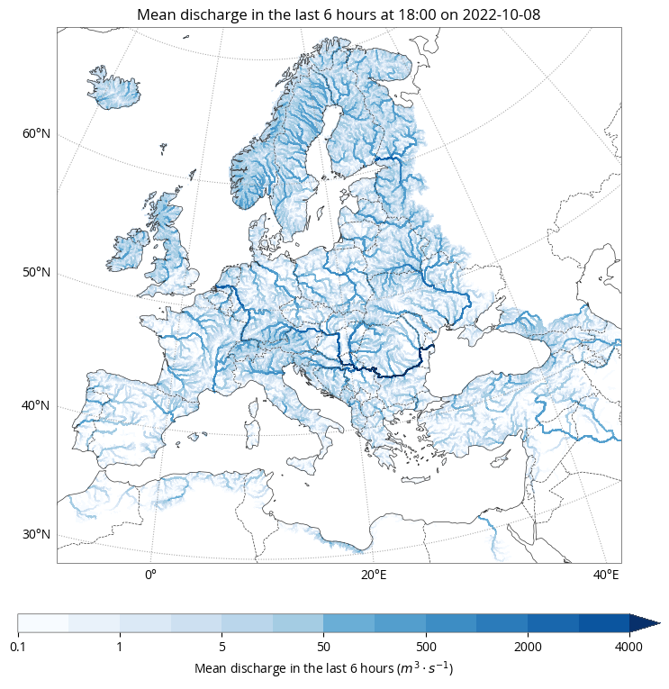
Non-equirectangular data
[11]:
earthkit.data.download_example_file("efas.nc")
data = earthkit.data.from_source("file", "efas.nc")
data.ls()
[11]:
| variable | level | time | units | |
|---|---|---|---|---|
| 0 | dis06 | None | None | m**3 s**-1 |
| 1 | land_binary_mask | None | None | 1 |
| 2 | upArea | None | None | M2 |
[12]:
data.to_xarray()
[12]:
<xarray.Dataset>
Dimensions:                       (y: 950, x: 1000)
Coordinates:
  * y                             (y) float64 5.498e+06 5.492e+06 ... 7.525e+05
  * x                             (x) float64 2.502e+06 2.508e+06 ... 7.498e+06
    time                          datetime64[ns] ...
    step                          timedelta64[ns] ...
    surface                       float64 ...
    latitude                      (y, x) float64 dask.array<chunksize=(950, 1000), meta=np.ndarray>
    longitude                     (y, x) float64 dask.array<chunksize=(950, 1000), meta=np.ndarray>
    valid_time                    datetime64[ns] ...
Data variables:
    dis06                         (y, x) float32 dask.array<chunksize=(950, 1000), meta=np.ndarray>
    lambert_azimuthal_equal_area  int32 ...
    land_binary_mask              (y, x) int8 dask.array<chunksize=(950, 1000), meta=np.ndarray>
    upArea                        (y, x) float32 dask.array<chunksize=(950, 1000), meta=np.ndarray>
Attributes:
    GRIB_edition:            2
    GRIB_centre:             ecmf
    GRIB_centreDescription:  European Centre for Medium-Range Weather Forecasts
    GRIB_subCentre:          0
    Conventions:             CF-1.7
    institution:             European Centre for Medium-Range Weather Forecasts
history: 2022-11-10T10:57 GRIB to CDM+CF via cfgrib-0.9.9...[6]:
earthkit.maps.quickplot(data[0])
{'central_latitude': 52.0, 'central_longitude': 10.0, 'false_easting': 4321000.0, 'false_northing': 3210000.0}
{'ellipse': 'GRS80'}
{'central_latitude': 52.0, 'central_longitude': 10.0, 'false_easting': 4321000.0, 'false_northing': 3210000.0}
{'ellipse': 'GRS80'}
{'central_latitude': 52.0, 'central_longitude': 10.0, 'false_easting': 4321000.0, 'false_northing': 3210000.0}
{'ellipse': 'GRS80'}
Reduced gaussian grids
[7]:
data = earthkit.data.from_source(
    "url",
    "https://get.ecmwf.int/repository/test-data/earthkit-regrid/test-data/global_0_360/O32.grib",
)
data.ls()
[7]:
| centre | shortName | typeOfLevel | level | dataDate | dataTime | stepRange | dataType | number | gridType | |
|---|---|---|---|---|---|---|---|---|---|---|
| 0 | ecmf | 2t | surface | 0 | 20231010 | 1200 | 0 | an | 0 | reduced_gg |
[8]:
data.to_xarray()
[8]:
<xarray.Dataset>
Dimensions:     (number: 1, time: 1, step: 1, surface: 1, values: 5248)
Coordinates:
  * number      (number) int64 0
  * time        (time) datetime64[ns] 2023-10-10T12:00:00
  * step        (step) timedelta64[ns] 00:00:00
  * surface     (surface) float64 0.0
    latitude    (values) float64 ...
    longitude   (values) float64 ...
    valid_time  (time, step) datetime64[ns] ...
Dimensions without coordinates: values
Data variables:
    t2m         (number, time, step, surface, values) float32 ...
Attributes:
    GRIB_edition:            1
    GRIB_centre:             ecmf
    GRIB_centreDescription:  European Centre for Medium-Range Weather Forecasts
    GRIB_subCentre:          0
    Conventions:             CF-1.7
    institution:             European Centre for Medium-Range Weather Forecasts
history: 2023-12-11T16:22 GRIB to CDM+CF via cfgrib-0.9.1...[9]:
earthkit.maps.quickplot(data, units="celsius")
{'central_longitude': 0.0}
{'semimajor_axis': 6378137.0, 'ellipse': 'WGS84'}
{'central_longitude': 0.0}
{'semimajor_axis': 6378137.0, 'ellipse': 'WGS84'}
